


As Wyoming enters its peak thunderstorm season, residents may begin spotting ominous-looking clouds stretching toward the ground — but not every threatening shape in the sky signals a tornado, Cowboy State Daily reports.
Meteorologists are reminding the public about scud clouds, a common weather phenomenon that can resemble funnel clouds but pose no real tornado threat.
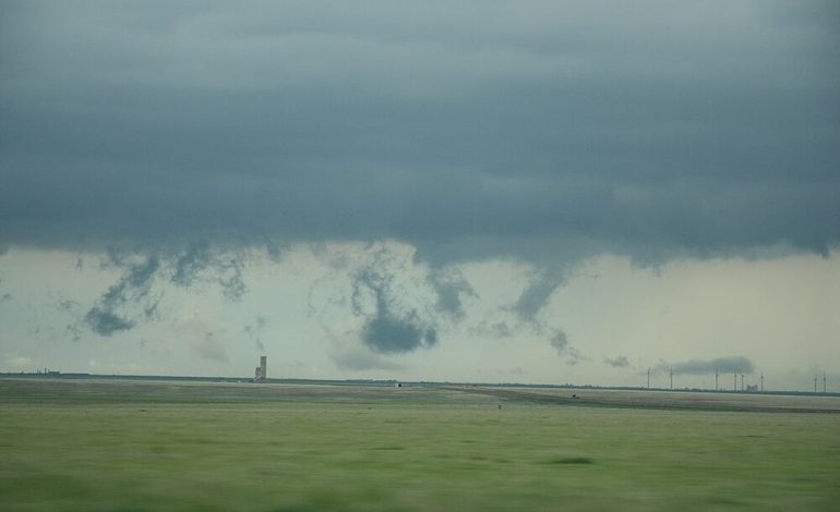
Scud clouds — or pannus clouds — are fragmented, low-hanging clouds that form beneath larger storm systems during periods of high moisture and turbulent air. According to meteorologist Don Day of Cowboy State Daily, scud clouds often appear during severe weather but are simply broken-off pieces of larger clouds, shaped by updrafts and downdrafts.
“You can get these little vortices that will spin off the base of a cloud and take a piece of cloud with it,” Day explained. “They can look scary, but they’re not dangerous in the way a tornado is.”
A video recently shared by AccuWeather from Maryland depicted what was described as a “white tornado,” later clarified as a scud formation — specifically, what some call a “scud vacuum.” However, Day points out that such terminology is misleading.
“Using the word ‘vacuum’ isn’t a good way to describe scud clouds, because there’s really no sucking going on,” he said. “They’re not drawing anything upward like a tornado does.”
Unlike tornadoes, scud clouds lack organized rotation. They often appear ragged or uneven, with cloud fragments drifting independently. Although they can occasionally spin or appear funnel-shaped, they do not produce the destructive winds associated with true tornadoes.
The American Meteorological Society explains that scuds can develop when raindrops break up in areas of high humidity or when evaporation from the ground creates additional moisture near the cloud base. Their presence typically coincides with heavy rainfall, hail, or gusty winds — not because they cause these conditions, but because they occur in the same storm systems.
While not as common in Wyoming as in more humid regions like the Mid-Atlantic, scud clouds do appear across the state during intense spring and summer storms.
“You need a good amount of moisture in the atmosphere to get scud clouds,” said Day. “In Wyoming, we usually only see that during severe thunderstorms.”
Scuds can occur anywhere across the state, especially in spring — Wyoming’s wettest time of year. The coming weeks may bring more opportunities to spot them, as several storm systems are expected to pass through. These may bring cooler temperatures, high-elevation snowfall, and the potential for thunderstorms.
With more precipitation and temperature swings in the forecast, residents should stay alert to changing conditions — but also know what they’re seeing.
“If a cloud starts rotating in an organized way and draws debris from the ground, that’s when you’ve got a tornado,” said Day. “If not, it’s likely just a scud.”
Despite their unsettling appearance, scud clouds are typically harmless. Their brief, fragmented nature sets them apart from more threatening storm phenomena — a reminder that not everything that looks dangerous from a distance actually is.

The latest news in your social feeds
Subscribe to our social media platforms to stay tuned