


The Cayman Islands are currently experiencing heavy rain and large waves as a tropical disturbance, located just west of the islands, threatens to rapidly intensify into a major hurricane, The Associated Press reports.
Forecasters warn that the storm could bring hurricane conditions to parts of Cuba and Mexico as early as Wednesday, followed by parts of Florida later in the week.
Hurricane watches have been issued for several areas including Florida’s Tampa Bay, from Englewood to Indian Pass, eastern Mexico from Cabo Catoche to Tulum, and Cuba’s Pinar del Rio province.
“Now is the time to start preparing,” said Lisa Bucci, a hurricane specialist at the National Hurricane Center (NHC). “If you’re in an evacuation zone, you should evacuate. Don’t be fooled by the way the storm looks at the moment. We are expecting it to rapidly intensify.”
The disturbance, expected to become Tropical Storm Helene on Tuesday, is predicted to strengthen into a Category 3 hurricane by Thursday as it approaches the northeast Gulf Coast. The NHC warns of significant storm surge, heavy winds, and widespread rainfall extending far from the storm’s center.
Given the anticipated size of the storm, the NHC has also warned of “inland penetration of strong winds over parts of the southeastern United States after landfall,” with potential rainfall impacting states like Tennessee, Kentucky, and Indiana.
The Cayman Islands, already facing heavy rain and waves of up to 10 feet, have closed schools and airports as a precaution. Meanwhile, concern is mounting in Cuba as the disturbance is expected to reach Havana, a city already struggling with severe water shortages and a backlog of uncollected garbage.
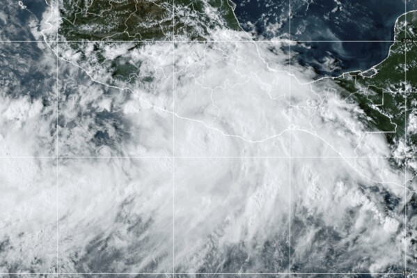
The National Weather Service in Tallahassee, Florida, is urging residents to take potential evacuations seriously. The disturbance is currently located about 150 miles west of Grand Cayman, with maximum sustained winds of 35 mph and moving northwest at 9 mph.
A weather disturbance is expected to move through the waters between Cuba and Mexico’s Yucatán Peninsula late Tuesday. It will then head north towards the Gulf Coast. Heavy rainfall is forecast for the southeastern U.S. starting on Wednesday, with the National Hurricane Center warning of potential flash flooding and river flooding. Up to 6 inches of rain is expected across the region, with some areas potentially seeing up to 10 inches.
Significant storm surge is also predicted for parts of Florida. The coast from Ochlockonee River to Chassahowitzka could experience a surge of up to 15 feet, while other coastal areas may see surges of up to 10 feet.
If the disturbance intensifies, it could become Tropical Storm Helene. This would be the eighth named storm of the current Atlantic hurricane season, which runs from June 1 to November 30. The National Oceanic and Atmospheric Administration has predicted an above-average hurricane season this year due to record-warm ocean temperatures. They forecast 17 to 25 named storms, with 4 to 7 major hurricanes reaching Category 3 or higher.