


University of Wyoming Launches New Portal for Statewide Access to LiDAR Elevation Data

The University of Wyoming’s Geographic Information Science Center (WyGISC) has launched a new public resource aimed at enhancing access to advanced geospatial data across the state, Wyoming News Now reports.
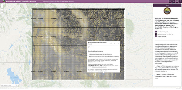
The Wyoming LiDAR Data Portal was officially introduced last week at the Wyoming Geospatial Organization’s Spring 2025 conference in Casper.
Developed under the direction of WyGISC and supported by UW’s School of Computing, the portal offers free access to high-resolution elevation and contour data collected through LiDAR (light detection and ranging) technology. The tool is designed to serve a broad audience, including researchers, planners, landowners, emergency managers, and members of the public.
“This is a major step forward in public access to high-resolution elevation data for the state of Wyoming,” said Shawn Lanning, a geospatial specialist at WyGISC.
Lanning helped develop the portal alongside project leader Jeff Hamerlinck and colleague Shannon Albeke.
The portal provides:
Statewide digital terrain models and 2-foot contour data derived from high-resolution LiDAR.
Centralized access to Wyoming-specific datasets and associated geospatial products.
User-friendly tools for data visualization, exploration, and downloads.
This effort was funded by a one-time $2 million legislative appropriation in 2023. The funding supported the creation of digital terrain models, 2-foot contour maps, and the portal itself. WyGISC partnered with geospatial engineering firm Woolpert to bring the project to completion.
The portal is intended to support a wide range of uses:
Landowners and developers can assess terrain for building or agricultural projects.
Researchers and educators can analyze geographic and environmental features.
Emergency services can use terrain data for disaster response planning.
Outdoor enthusiasts and drone users can better understand terrain and elevation.
Government agencies can integrate the data into infrastructure and resource management.
A second phase of the project is already underway and will focus on expanding data availability and enhancing tools based on input from stakeholders throughout the state.


The latest news in your social feeds
Subscribe to our social media platforms to stay tuned